RUBICON HERITAGE
  • Home
  • Services
    • Heritage and Archaeological Consultancy
    • Archaeological Fieldwork Services
    • Specialist and post-excavation services
  • Projects
    • Roads and Rail
    • Housing and commercial
    • Energy and Water
    • Public Amenities
    • Community Outreach
    • Post-excavation
  • About us
    • Rubicon Team
    • Vacancies
    • Fair Pay and Career Development
    • Health and Safety
    • Privacy Policy
  • Contact
  • Blog
    • Older posts

RUBICON HERITAGE BLOG

Five Mile Lane, Barry - eBook and StoryMap

21/3/2022

0 Comments

 
Picture
Cover of the eBook: Guide to the Excavations at Five Mile Lane
Rubicon are delighted to be able to share the results of our work at Five Mile Lane, Barry, Vale of Glamorgan in the form of an accessible eBook and an interactive StoryMap! 
The excavations were conducted in 2017 and 2018 by Red River Archaeology Group and uncovered a previously unknown multi-period landscape which has been used in a multitude of ways since humans first settled the Vale of Glamorgan.

​Please follow the links below to learn more!
The investigations were undertaken by Red River Archaeology Group (consisting of Rubicon Heritage Services and Red River Archaeology) in advance of the A4226 Five Mile Lane Improvement Scheme. The works were funded by Vale of Glamorgan Council and the main contractor for the scheme was Alun Griffiths. Thanks are due to Capita and Cotswold Archaeology, consultants to the Council for the project, and to Glamorgan Gwent Archaeological Trust, the National Museum of Wales and Cardiff University for their assistance and support during the project.
Picture
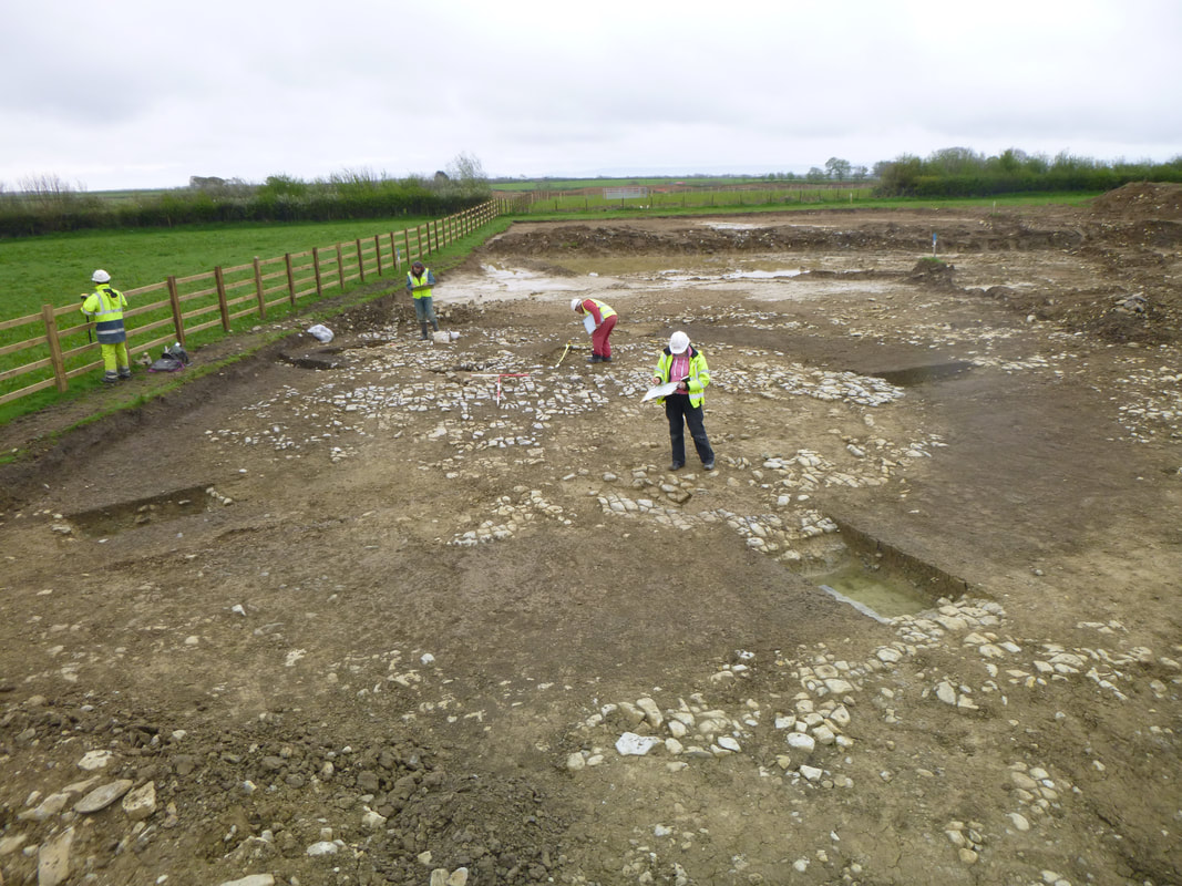
Iron Age penannular ditch enclosure under excavation at SMR19c
From a ceremonial and funerary landscape in the Neolithic and Bronze Age periods, through to farming in the Iron Age and being part of a wealthy Roman farmstead, to a Medieval burial ground which reused the earlier burial mound, and finally to the post-medieval agricultural landscape we see today, the archaeologists were able to trace the development of this swathe of land, uncovering many surprises along the way.
Please read our eBook to discover more about the project!
The eBook was written by Rachel Morgan with contributions from Dave Gilbert, Rose Calis, Vicky Rees and Siobhan Sinnott. The eBook was produced and illustrated by Jonathan Millar.
​
You can also explore the project using our interactive StoryMap - see where the sites were and what was found!

The StoryMap was created using content and images gathered and created initially for the eBook. It was produced by Jonathan Millar and edited by Rachel Morgan and Dave Gilbert.
​
0 Comments

Your comment will be posted after it is approved.


Leave a Reply.

    Archives

    March 2022
    November 2021
    September 2021
    June 2021
    April 2021
    March 2021
    February 2021
    January 2021
    December 2020
    November 2020
    October 2020
    September 2020
    August 2020
    July 2020
    June 2020
    May 2020
    February 2020

    Categories

    All
    Adobe Software
    Analysis
    Archaeological Evaluation
    Archaeological Excavation
    Archaeological Illustration
    Archaeological Impact Assessment
    Archaeological Planning
    Archaeological Risk Management
    Archaeological Testing
    Archaeology
    Archaeology Ireland
    Archaeology Wales
    Architecture
    Archive
    Archiving
    Artillery
    Bridge
    Bronze Age
    California
    Castle
    Cemetery
    CIfA
    Civil Engineering
    Clonakilty
    Coastal Defence
    Compliance
    Conflict Archaeology
    Construction
    Continuing Personal Development
    Cork
    Cork City
    Cork County Council
    County Clare
    County Cork
    County Kerry
    County Tipperary
    Covid-19
    Desk Based Assessment
    Development
    Dezallier D’Argenville
    Disability
    Dublin
    Dunkettle House
    Education
    Energy Sector
    Environmental Management
    Excavations
    Famine
    Flood Alleviation
    Geomatics
    Geophysical Survey
    Gold
    Grail
    Grangegorman
    Great Famine
    Great Hunger
    Great Starvation
    Ha-ha
    Health And Safety
    Heritage
    Heritage Planning
    Historic Buildings
    Holy Relic
    Housing
    Immortality
    Ireland
    Irish Potato Famine
    John James Architect
    Killaloe
    Landscape
    Medieval
    Midleton
    Miraculous
    Napoleonic Defence
    Offaly
    Osteoarchaeology
    Outreach
    Planning Permission
    Post-excavation Analysis
    Post Medieval
    Post-medieval
    Publication
    Quality Management
    Reconstruction Graphics
    Roads
    Rubicon Heritage Services
    Solar Energy
    StoryMap
    Survey Training
    Terry Pratchett
    Tourism
    Training
    Transport Infrastructure Ireland (TII)
    USA
    Webinar

This section will not be visible in live published website. Below are your current settings:


Current Number Of Columns are = 2

Expand Posts Area =

Gap/Space Between Posts = 10px

Blog Post Style = card

Use of custom card colors instead of default colors =

Blog Post Card Background Color = current color

Blog Post Card Shadow Color = current color

Blog Post Card Border Color = current color

Publish the website and visit your blog page to see the results

Picture
Picture
Picture
Picture
Picture
Picture
Picture
Picture
Picture

Cork Rubicon Office
T:+353 (0) 214 520 286
​

​DUBLIN RUBICON OFFICE
T:+353 (0) 143 726 26

Copyright© 2022 Rubicon Heritage Services Ltd. All rights reserved.